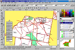
All-in-one software for creation of custom GPS maps compatible with Garmin GPS units. Mapwel supports routing, ESRI shapefiles, OpenStreetMap OSM, Google Earth KML and KMZ, cGPSmapper MP and GPX files. Mapwel custom GPS mapping capability and user icons editor are often used in forestry, electrical engineering, geology and geodesy. Creation of a GPS map involves georeference of raster images, drawing of the vector map, import of data from various file formats and online sources, conversion of the map data into the native format of the GPS and upload of that data into the GPS. Mapwel is the only available mapping software compatible with Garmin GPS units that allows the user to do the all above steps with a single software tool. Mapwel uses its own map compiler.
System Requirements:
WinXP, WinVista, WinVista x64, Win7 x32, Win7 x64, Win8 x64, Win2000, Win98
Version:
Build-11.0-2013
Last updated:
2013-01-16 21:23:00
Publisher:
BALARAD, s.r.o.
Homepage:
http://www.mapwel.netFile name:
mapwel64_setup.zip
File size:
20.72MB
License:
Shareware
Price:
45.00