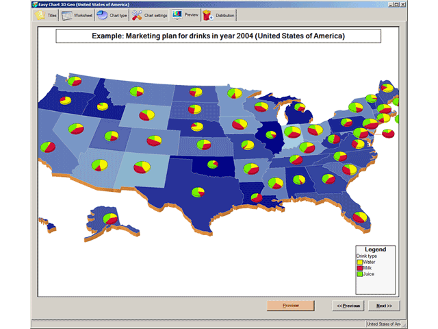
Easy Chart 3D GEO is easy to use wizard-like graphical reporting tool for effortless generation of complex business, management, financial and ad-hoc geographical pie charts (cylinder and cube shapes also available) of professional quality. Charts are generated on a top of a 3D geographical maps. Geographical Maps that are available: USA by states, USA states by counties, Europe by countries, Germany, Italy, United Kingdom, Spain, France, Austria, Australia, custom made maps and other on-demand maps.
Direct connection to Microsoft SQL Server, MS Access, Oracle and other databases (via ODBC) is available to fetch data from business systems (no place for human errors and very fast). Also, data can be Cut and Pasted from Microsoft Excel worksheets.
Graphical charts may be sent directly via email ('fire-and-forget' no-garbage technology) or saved to disk for later use in HTML WEB pages, business reports, marketing presentations or business meetings (suitable for LCD projectors and Screen Wall presentations).
Reports can be generated for English, German, Spanish, Italian, Chinese, Japanese or any other language (Unicode compatible).
Different output formats supported: 1) for image generation JPG (JPEG), TIFF, BMP, GIF, WMF and PNG format, 2) for animated reports AVI (Audio-Video Interchange) format so you can virtually 'fly over' your business regions and 3) smartCh@rt format (standalone interactive graphical business report format that does not require viewer on client side). SmartCh@rt is especially good for human communication inside organizations and companies because it promotes Paperless Office philosophy. Supports image resolutions from 200x200 to 2000x2000 pixels and 24-bit color depth. DirectX or OpenGL is NOT required.
For shorter transfer times and smaller memory footprint, ZIP compression option is available.
24-hour support team. Fast custom chart design team.
Get more info about program at GeoBrush's International site www.geobrush.com
System Requirements:
Win98, WinME, WinNT 4.x, Windows2000, WinXP, Windows2003
Version:
1.1
Last updated:
2010-05-05 15:28:05
Publisher:
GeoBrush International
Homepage:
http://www.geobrush.comFile name:
EasyChart.exe
File size:
8.11MB
License:
Shareware
Price:
135